Nine Standards, Coast to Coast
More Articles in the Kirkby Stephen to Keld subsection
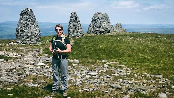
Carol and Nine Standards Rigg
Nine Standards, Hartley Fell, Coast to Coast
Nine Standards Rigg is 4 miles south east of Kirkby Stephen and sits on the ridge top of Hartley Fell, a vast mist-ridden blanket bog full of gulleys, marsh and quagmire. Many of its named features describe Hartley Fell and its bogland plateau quite well with names such as Standards Mire, Bastifell Bog, Millstone Haggs and Peatpot Hill. In clement weather the Coast to Coast path on Hartley Fell is not too difficult to follow, but in misty, moisty weather it is unpleasant and difficult.
The Nine Standards
Approaching the Nine Standards from the path along Faraday Gill, you can see all of the cairns at once. The Standards sit on a subsidiary summit of Hartley Fell, at 650m, the true summit of 662m being flagged by the trig cairn, 100 yards further south.
Nine Standards Hartley Fell
The climb to the Nine Standards along Faraday Gill is a steep and long climb, but the path is easy to follow. The Red and Blue Routes of the Coast to Coast path share this part of their route and do not diverge until reaching Near Grains, a half mile further along the path.
Glacial & Periglacial Geography at Nine Standards Rigg
Summit Plateau
Nine Standards Rigg forms part of a broad upland plateau shaped by prolonged glacial erosion and subsequent periglacial modification.
Ice Margin Influence
During the last glaciation, ice from the Eden Valley and Swaledale influenced the surrounding landscape, though the highest ground may have remained close to the ice margin.
Periglacial Weathering
Freeze–thaw processes in intensely cold, ice-free conditions fractured the bedrock, contributing to blockfields and surface stone scatter.
Peat Formation
Poor drainage on the plateau following ice retreat led to extensive peat development, creating the characteristic boggy ground of the summit ridge.
Patterned Ground
Subtle surface sorting of stones reflects periglacial processes active after the main glaciers had retreated.
Human Landmarking
The Nine Standards cairns stand on this exposed plateau, built long after glaciation but positioned within a landscape shaped by cold-climate processes.
Nine Standards
The Nine Standards are nine large dry-stone, conical cairns, that lie in file along the edge of the Rigg. They are at least 800 years old. Recent evidence indicates that there may once have been thirteen cairns. Their origin is not known. It is speculated that there could be a long barrow beneath the cairns.
Nine Standards
The elevation of Nine Standards Rigg is 650m. Some of the cairns once stood up to 4m high. These huge cairns are in the North Pennines Area of Outstanding Natural Beauty (AONB). The cairns are a little lower than the summit cairn, (662m) about 100m further along the path.
Millstone Spring Brownber Head
From Nine Standards Rigg the view to the north east is across Millstone Rigg. Millstone Spring's wide trough wends eastwards from the Spring to Winton Force. Noticebly elevated (600m) in the distance is Brownber Head, its mesa outline quite unmistakable.
Bastifell
Nine Standards Rigg is higher than the surrounding land. The view to the north, just over the dip of the Rigg, is of Bastifell, Bastifell Bog and Standards Haggs. There is no defined path across this part of Hartley Fell, and in wet weather passage across it would be treacherous.
Hartley Fell Trig
The Ordnance Survey trig marks the summit of Hartley Fell as 662m. The Coast to Coast path lies in a straight line from the Nine Standards to the trig. Following the edge of he ridge the path pursues another straight course to White Mossey Hill, which is 659m.
Nine Standards Hartley Trig
Looking back from a cairn midway from Nine Standards to Near Grains , about a quarter mile, the Nine Standards can still be seen, even in mist. The summit trig can also be seen to their left. From this point on until reaching Millstones, the path is criss crossed with bogs, deep gutters and rills, a distance of about 1.5 miles.
Coast to Coast Trail Guide
Hiking the Coast to Coast
"Hiking the Coast to Coast" is a digitally enhanced eBook available from Apple Books for all people who have either a Mac, an iPhone or an iPad, and is designed to accompany you on your walk of the Coast to Coast path. The trail guide contains Ordnance Survey maps and other advanced mapping features, step by step directions, hundreds of colour photographs, details of the route, its conditions in different weather and research snippets relating to places of interest along the way.
