Round Hill, Urra Moor, Coast to Coast
More Articles in the Clay Bank to Lion Inn subsection
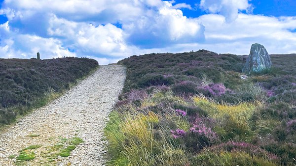
Coast to Coast path climbing towards Round Hill. Urra Moor Standing Stone is on the right, and a Feversham Boundary Stone on the left.
Round Hill, Urra Moor, Coast to Coast
Round Hill is the highest part of the North Yorkshire Moors, and is the summit of Urra Moor. To the north of the summit cairn is Botton Head, from where the Ingleby Beck springs. Round Hill summits at 454m. The Coast to Coast path climbs very close to the summit, marginally passing it by to the south. The gentle climb to the summit from the west sees the path navigating past a number of standing stones and barrows, including the Face Stone and Hand Stone.
The area around the summit of Round Hill has a number of diverging paths; two head west, one to the hamlet of Urra and the other to the hamlet of Seave Green. Another heads south to North Gill Head where there is a large boulder containing ancient rock art within an ancient stony earthwork. The rock contains cup and ring marks which form an occulus motif. A further path heads south east over Cockayne Head, providing access to the Badger Stone. A line of Feversham Boundary Stones continue from Carr Ridge, to end at the top of Round Hill. Not far east of Round Hill is Bloworth Crossing, a junction of major pathways that cross this area of moorland
Urra Moor Standing Stone
The gentle western incline to the summit of round Hill passes between a large Standing Stone and a couple of Feversham Boundary Stones. This Standing Stone is of a significant size and sits close to a Stony Earthwork which can be seen in the near distance. The main part of the Earthwork rolls west to merge with the long Urra Moor west perimiter Eathwork, and part breaks off south to North Gill Head.
Feversham Boundary Stones
From the Urra More Standing Stone there is a Line of Feversham Boundary Stones bearing from Round Hill, towards Raisdale.
Prehistoric Landscape at Round Hill
Bronze Age Cairns
The stone cairns on Round Hill are Bronze Age burial monuments, typically dating from around 2000–1500 BC.
Skyline Positioning
These cairns were deliberately placed on high, visible ridges, marking territory and memorialising the dead across the open moor.
Funerary Practice
Many such cairns contained cremation burials placed within stone-lined cists beneath the mound.
Ritual Landscape
Round Hill forms part of a wider prehistoric landscape of barrows and linear earthworks scattered across the North York Moors.
Route Continuity
Ancient ridgeways later became medieval drove roads and now form sections of modern long-distance paths, including the Coast to Coast.
Round Hill West Round Barrow
The Round Barrow located about 300m west of the trig on Round Hill is a Bronze Age burial cairn. The burial mound is 14m wide. On top of the Round Barrow is a congregation of stones placed there, presumably, to flag the Barrow's existence. The Barrow was once surrounded by a 3m wide ditch but this has now become filled and now appears as an ancient earthwork.
Botton Howe
Botton Howe Round Barrow occupies the 494m summit of Round Hill. It comprises a 2m high earth and stone mound and is 23m wide. The surrounding ditch has been naturally filled and is no longer visible. A narrow path from the Coast to Coast provides easy passage to the Barrow. A modern trig has been placed atop the Barrow.
Hand Stone
The Hand Stone is also known as the Round Hill East Stone and the Urra Moor Hand Stone. Its locus is, unsurprisingly, about 100m due east of Round Hill, and sits beside the Coast to Coast path. The function of the Stone is to act as a Guide Stone, and to this end the rear of the stone has etching that reads, according to R H Hayes, author of "Old Roads and Pannierways in NE Yorkshire", "This is the way to Kirby" meaning Kirbymoorside.
Face Stone Round Hill
The Face Stone is an ancient Boundary Stone, first known to exist in 1642 when it was mentioned as such in the Preamble to the Duncombe Estate. It is often referred to as the Face Cross. Not much is known about the origins of the Stone. There is possibly a buried extension of the stone containing a socket upon which the face shaft is fixed. It is also possible that the Stone is a lot older than the date above mentioned.
Coast to Coast Trail Guide
Hiking the Coast to Coast
"Hiking the Coast to Coast" is a digitally enhanced eBook available from Apple Books for all people who have either a Mac, an iPhone or an iPad, and is designed to accompany you on your walk of the Coast to Coast path. The trail guide contains Ordnance Survey maps and other advanced mapping features, step by step directions, hundreds of colour photographs, details of the route, its conditions in different weather and research snippets relating to places of interest along the way.
