Isles Bridge, Low Row, Coast to Coast
More Articles in the Keld to Reeth subsection
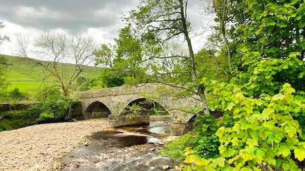
Isles Bridge, Low Row, Swaledale
Isles Bridge, Low Row, Swaledale, Coast to Coast
Isles Bridge is a multi-arched stone bridge spanning the River Swale, named after the nearby, terraced hamlet of Isles, close to Hatter's Roof and Low Row. Three main arches span the main channel of the Swale, but several other arches extend to the bridge's north side, some of which are hidden in dense riverbank vegetation.
The lower route of the Keld to Reeth section of the Coast to Coast path passes just north of Isles Bridge as it descends into Low Row from Great Rowleth and Smarber. The south side of the bridge connects to Crackpot.
Isles Bridge Swaledale
Isles Bridge connects the villages of Crackpot and Low Row. It is a long multi-arched bridge spanning the River Swale on a north convexity of the River. Elevated above the Swale's north arc is the small, modernised mining hamlet of Isles.
Isles Bridge is Multi Arched
The River Swale floods regularly and provision has been made for this in the design of Isles Bridge. In addition to the 3 main arches there are at least 5 more where the bridge spans the earth on the north riverbank, this being part of the Swale's flood plain.
River Island Swaledale
West of Isles Bridge is a large river island that is made up of an exposed, elevated floor of pebbles and rocks. On hot, sunny, summer days 'pebble island' is often host to paddlers and sunbathers. There is room on the bridge and nearby for car parking.
Riverside Path Isles Bridge
The riverside path leading to the Swale is festooned with a dense carpet of flowering wild garlic. The vegetation is dense but pleasant.
Hamlet of Isles
The hamlet of Isles was once home to the miners working the nearby Friar Intake Lead Mine, now disused. This mine was in regular use for 200 years, between the 17th and 19th centuries, extracting galena from a rich vein known as the Friar Intake Vein.
Isles Bridge from Friar Intake
The vein of galena mined at Friar's Intake stretched uphill onto Melbecks Moor. The mine consisted of a level just short of 2,000 feet long, with several shafts and bell pits. The low level spoil dump can still be seen on the north side of the B6270, between Great Rowleth Wood and Isles, enclosed within a stone wall.
Take the Coast to Coast Guide With You
Available on Apple Books — £12.99
Hiking the Coast to Coast combines step-by-step route directions, interactive mapping, hundreds of original photographs and information about the landscapes, history and places encountered along the route.
© 2026 Roy McKee · Coast to Coast
Contact - Privacy. - Terms