Gatescarth Pass, Mardale - Coast to Coast
More Articles in the Patterdale to Haweswater subsection
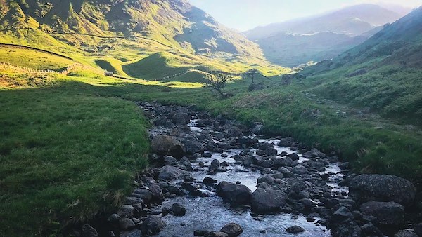
Mardale Beck at Mardale Head
Gatescarth Pass, Mardale - Coast to Coast
Gatescarth Pass is the historic mountain crossing between Harter Fell and Branstree, dividing Sleddale Fell from the long back of Kentmere Pike. Beginning at Mardale Head, the route follows Gatescarth Beck through a narrowing valley before climbing steadily to the col between the two summits. From here it descends into Longsleddale, finishing on the quiet lane at Sadgill. Although best known to fell walkers, the track is also used by mountain bikers and, once a month in summer, by trail riders and 4×4 vehicles operating under a strict permit system limited to twelve places.
Gatescarth Pass Summit Junction
At the col between Harter Fell and Branstree an important meeting of paths forms the heart of Gatescarth Pass, with routes radiating towards four distinct valleys. To the west the line rises towards the rocky spine of Harter Fell, while to the east it climbs the gentler slopes of Branstree. Northwards the stony track descends into Mardale Head beside Gatescarth Beck, and southwards it falls into the long, narrow sweep of Longsleddale. This quiet saddle has long served as a natural crossroads for travellers moving across the eastern fells.
Glacial Geography at Gatescarth Pass
Glacial Col
Gatescarth Pass occupies a high col formed where glaciers eroded back-to-back from opposite valleys, lowering the ridge between Mardale and Longsleddale.
Headward Erosion
Ice flowing eastwards towards Haweswater and southwards towards Kentmere cut into the ridge, narrowing it into the present pass.
Arête Development
The ridges leading to Harter Fell and Branstree display arête characteristics, sharpened by glacial erosion on both sides.
Scree Slopes
The loose, shifting scree on the Mardale side reflects post-glacial weathering of frost-shattered rock rather than active erosion.
Historic Routeway
Although shaped by ice, the pass later became an important packhorse and drove route between valleys.
Modern Surface Instability
The unstable stone surface today is largely the result of vehicular damage interacting with already fragile glacial debris.
Gatescarth Pass Watershed Col
Looking back towards the crest of Gatescarth Pass, the steep, rising flanks of Harter Fell and Branstree frame the narrow saddle that forms the watershed between north and south. Here the flow of water divides cleanly: to the north it gathers into Gatescarth Beck on its way to Haweswater, while to the south it drains towards Sadgill before joining the River Kent. The view emphasises both the height and the purpose of the pass, a natural divide shaped by gradient, geology and watercourse.
Gatescarth Pass
Upon joining Gatescarth Pass from the flank of Harter Fell, the landscape begins to reveal itself in steep, fragmentary glimpses. To the west the sharp declivities of Harter Fell Gully drop away beneath broken crags; to the east the slopes of Branstree fall in long, grassy angles. Ahead, the ridge of the Dudderwick rises and narrows towards the northern approach to Mardale. These features, emerging through drifting mist, give the descending path its distinctive mixture of enclosure, gradient and sudden, dramatic openings.
Gatescarth Beck Mardale Path
From Mardale Head the rough stone footpath climbs beside Gatescarth Beck, the two routes sharing the broad upper basin of the pass before narrowing towards the junction below Branstree. Here the valley floor is wider and more open, with the beck running in a lively, stony channel while the path keeps close company on its eastern bank. As the ascent progresses the landscape tightens, guiding walkers towards the higher watershed where the track steepens and the views begin to gather around the surrounding fells.
View toward Small Water
Near the coniferous coppice on the descending side of Gatescarth Pass, the path reaches a gentle brow where the view suddenly lifts up the Mardale Valley towards the corrie holding Small Water. From here the eye follows the line of the ravine feeding the tarn, with the bright cascades of Small Water Beck visible in the distance as it tumbles over dark rock shelves. The opening is brief but striking, revealing the high basin and its waters framed by steep, converging slopes.
Haweswater - Mardale Descent
On the brow of the final descent into Mardale, Haweswater first reveals itself through a gap around the flank of Branstree, a sudden glimmer of open water after the confines of the pass. In the same moment the ridge of the Dudderwick and the sloping tongue of The Rigg spring into view, with the broken tiers of Whelter Crags rising on the far shore. It is a dramatic unveiling, the landscape widening swiftly as the path drops towards the valley floor.
Mardale Head - Pass Terminus
At Mardale Head the northern end of Gatescarth Pass is reached, the path having traced the course of Gatescarth Beck from the high col to its meeting with Haweswater. Here the beck spills into the reservoir only metres from the inflow of Mardale Beck, the two waters converging beneath the steep valley walls of the Dudderwick. Passing through a simple gate marks the end of the pass and the transition from upland crossing to lakeside terrain, with the surrounding slopes rising sharply in folded tiers above the head of the valley.
Take the Coast to Coast Guide With You
Available on Apple Books — £12.99
Hiking the Coast to Coast combines step-by-step route directions, interactive mapping, hundreds of original photographs and information about the landscapes, history and places encountered along the route.
© 2026 Roy McKee · Coast to Coast
Contact - Privacy. - Terms


