Rooking, Patterdale, Coast to Coast
More Articles in the Patterdale to Haweswater subsection
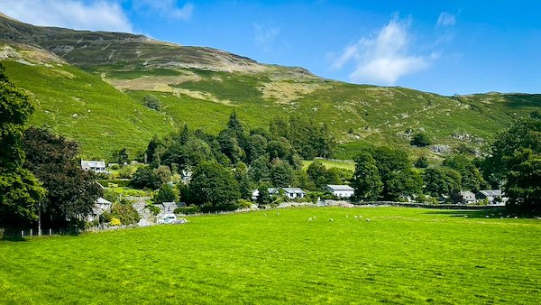
Approaching Rooking from Goldrill Bridge
Rooking, Patterdale, Coast to Coast
Rooking is a small Lakeland hamlet set at the very foot of Patterdale Common, lying directly on the line of the Coast to Coast path as it turns east from Patterdale towards Haweswater via Boredale Hause. Just a quarter of a mile from the village, it is reached by a short uphill pull along a minor road, rising gently between stone cottages and neatly tended, flower-filled gardens. Behind the hamlet, the open expanse of the Common lifts steeply, with Place Fell and Round How providing a broad and dramatic backdrop. Coast to Coast walkers are guided through Rooking almost as soon as they arrive, a prominent fingerpost directing them sharply right and up onto the Common, leaving the settled valley behind for the long, airy crossing towards the eastern fells.
Rooking
The stone cottages of Rooking sit quietly at the foot of Patterdale Common, their orderly forms and well-tended gardens giving the hamlet a settled, almost timeless air. Rising directly behind them, the long green flank of Place Fell provides a broad and protective backdrop, lifting the scene from valley intimacy to open fellside. The contrast between cultivated enclosure and rising commonland gives Rooking its distinctive character — a brief moment of domestic calm before the Coast to Coast path turns sharply uphill and leaves habitation behind.
Place Fell from Rooking
From the edge of Rooking, the view opens across enclosed pasture towards the broad lower slopes of Place Fell, where the Coast to Coast path can be traced as it contours steadily eastwards. The line of travel is clear, rising gradually across the fell’s lower face before turning towards Boredale Hause. This outward-looking perspective neatly frames the journey ahead, linking the settled fields of the valley floor with the open, transitional ground that leads onto the higher commons beyond.
Crookabeck Patterdale Valley
The approach to Rooking from Goldrill Bridge crosses the fertile floor of the Patterdale valley, stretching between Brothers Water and Ullswater. Here, Goldrill Beck regularly overtops its banks, depositing rich silts that nourish the surrounding fields. Looking south towards Crookabeck, the result is unmistakable: deep green pasture, soft ground underfoot, and a valley shaped as much by seasonal flooding as by farming, its quiet productivity evident long before the path begins to climb.
Goldrill Beck and Glenridding Dodd
Goldrill Beck forms the outflow of Brothers Water, winding north through the Patterdale valley on its short journey to Ullswater. Passing beneath Goldrill Bridge, the beck marks a natural corridor between enclosed pasture and rising fellside. Looking upstream from the bridge, the water draws the eye towards Glenridding Dodd, its rounded profile closing the view and lending the scene a quiet sense of scale and direction before the route turns east towards the open ground beyond Rooking.
Goldrill Bridge Rooking
Goldrill Bridge carries the route across Goldrill Beck between Patterdale and Rooking. Built as a narrow single-lane stone crossing, its two low arches span the beck at a natural narrowing of the valley floor. On the eastern, Rooking side of the bridge, a circular footpath begins, following Rooking Gill downstream to a smaller footbridge near the recreation ground and school. Turning right at this junction completes a gentle circuit via Side Farm, crossing open fields before returning to Goldrill Bridge.
Goldrill's Meanders
Sections of Goldrill Beck have now been successfully restored to a more natural, meandering course across the valley floor. Earlier artificial straightening has been reversed, allowing the beck to reconnect with its floodplain and slow naturally during periods of heavy rain. Led by the National Trust as part of wider catchment management work, the reshaping of the channel has reduced pressure on the A592 — the only road linking Patterdale and Rooking with Ambleside and Windermere. The re-established bends, gravel bars and wet margins now form a living part of the landscape, showing how working with natural river processes can restore both ecological balance and practical resilience.
Cow Bridge to Beckstones
The most flood-sensitive stretch of the valley lies between Cow Bridge, just east of Hartsop, and Beckstones Farm, where Goldrill Beck meets Deepdale Beck. The broad, level fields here are natural floodplains, formed from centuries of deposited silt and gravel. Historically, the beck wandered freely across this alluvial ground, spilling excess water away from the road during periods of heavy rain. By allowing the channel to return to this natural pattern, floodwater is absorbed by the fields rather than forced onto the A592, restoring a balance between river, land and infrastructure that long predates modern engineering.
Hiking the Coast to Coast trail guide
Hiking the Coast to Coast is a digitally enhanced eBook designed to accompany you on your journey along the Coast to Coast path. Available on Apple Books for iPhone, iPad and Mac, the guide includes:
• Mapping with interactive features
• Step-by-step route directions
• Hundreds of colour photographs
• Route conditions in different weather
• Historical and cultural points of interest
Whether you’re planning your trip or already on the trail, it’s a practical and beautifully illustrated resource to carry with you.


