Raisdale, Chop Gate, Coast to Coast
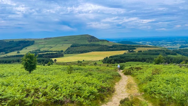
Carlton Moor from the far side of Raisdale west.
Raisdale, Chop Gate, Coast to Coast
Raisdale is a Y shaped valley, the western length of which lies between Bilsdale Moor West and Cringle Moor, and the eastern length of which lies between Cringle Moor and Cold Moor. As the valley extends south the two sections of Raisdale merge and the Raisdale Beck West, which flows through the west section merges with the Raisdale Beck East, which flows through the east section. The confluence of the two Becks is at Raisdale Mill. The Raisdale Beck is subsumed by the Bilsdale Beck a little to the south of Chop Gate.
Bilsdale West Moor forms a high moorland wall around Raisdale from the Valley's north west at Lord Stones to Chop Gate. Bilsdale West Moor then continues south where it forms the west valley wall to Bilsdale until reaching Easterside.
Raisdale West
Raisdale at Lord Stones
From the north finger of Bilsdale West Moor there is a sweeping view of the north west arc of Raisdale as it reaches the valley head at Lord Stones. Cringle Moor is seen opposite with the tree lined Raisdale Beck in the valley floor.
Cringle Moor South Fork Farm
The wide-ranging view across Raisdale from Bilsdale West Moor allows a view of the entire eastern scarp of Cringle Moor, with Cold Moor coming into view further along. The woodland below the Cringle Scarp is Harry Wath Wood and abutting the foot of the woodland is South Fork Farm.
Bilsdale West Moor
Seen from Cringle Moor the north finger of Bilsdale West Moor is on the opposite side of Raisdale. The large woodland is un-named but lies a little further up the valleyside than Low Broomflatt Farm and a little to the north of Staindale Farm. The woodland closer to Cringle Moor is Harry Wath Wood.
Low Broomflatt Farm
Low Broomflatt Farm is located just east of Raisdale Beck and its ribbon woodland. A little further west from the Beck is a large unnamed conifer woodland that assumes a sizeable portion of the east face of Bilsdale West Moor. Adjacent to the Farm is High Broomflat, a little further north.
Cringle Tail
The southern tip of Cringle Moor finishes with a curved tip. Cringle Moor Plantaiton forests the west and east faces of Cringle Moor, each side of the Cringle tail. Its southern tip descends into a curved tail and onto rough grass opposite to High and Low Broomflatt Farms.
Wath Hill
Wath Hill is a small 308m hill that backs onto Raisdale Beck, deflecting it south and into Raisdale Mill Plantation. The Hill is shielded from the north east by a small shelterbelt of coniferous trees. A finger of woodland stretches east from Raisdale Beck's ribbon companion, filling the depressed land to the north east of the Hill.
Raisdale East
Head of Raisdale Valley East
The head of the east wing of Raisdale Valley is the col between Cringle Moor and Cold Moor. The steep valley falling away to the north births the Trows Beck. The large yellow field contains three tumuli, each of which are scheduled monuments. Two lie 40m apart about 2/3 of the way towards the south boundary wall.
Twin Tumuli Raisdale East
Between the two tumuli in the col at the head of Raisdale East, there are believed to be a number of ancient flat graves. The twin tumuli are Round Barrows each with an earth and stone mound. A further Round Barrow lies close to the north west field wall, but is less conspicuous.
Beak Hills Farm
Beak Hills Farm is a notable landmark when viewing Raisdale from the Coast to Coast path on Cringle Moor. As well as being a working farm the property also provides bed and breakfast facilities and camping.
Raisdale East Looking South
From the north west butt of Cold Moor a scenic meadowscape catches the eye and directs it along the throat of Raisdale towards Raisdale Mill. The woodland is Cringle Moor Plantation and the ribbon of trees below, shadow Raisdale Beck East.
Raisdale South
Barker's Ridge Raisdale
Looking west from Stone Intake Farm, Barker's Ridge at 340-350m dominates the skyline. Below the Ridge is an un-named Woodland due west of High and Low Crosslets Farms. The Farms are just visible above the ribbon trees of the Raisdale Beck.
Bilsdale West Moor Raisdale
The south wall of Raisdale Valley comprises Bilsdale West Moor and Bilsdale East Moor. Between the two is a large gap through which the Bilsdale Valley stretches southward. At the top of Bilsdale West Moor is the Bilsdale transmitting Station, its huge mast visible from all around, and indeed used by many ramblers from which to take their bearings.
Stoney Wicks Billsdale Moor
Between Raisdale Mill Plantation and an unnamed plantation further south there is a wide gap, so that when looking west from Cold Moor End there is a clear view between the Plantations to the purple heath of Stoney Wicks, a location often visited by boulderers. Below Stoney Wicks is High Crosslets Farm.
Raisdale Mill Plantation
When looking along the throat of Raisdale Mill, following it towards the head of Raisdale Beck, Carlton Moor is seen on the skyline, cloaked with a mask of purple heather.
Stone Intake Farm Raisdale
Stone Intake Farm is positioned at the south west foot of Cold Moor in the south section of Raisdale Valley. An Intake relates to a parcel of land on the margin of a moorland which is taken in to the farm to be farmed. The usual way to begin such a process is to erect a wall barrier around the intake land and introduce sheep or cattle to graze it. The intake land is normally acidic grassland with moorland rushes and bilberry.
Coast to Coast Trail Guide
Hiking the Coast to Coast
"Hiking the Coast to Coast" is a digitally enhanced eBook available from Apple Books for all people who have either a Mac, an iPhone or an iPad, and is designed to accompany you on your walk of the Coast to Coast path. The trail guide contains Ordnance Survey maps and other advanced mapping features, step by step directions, hundreds of colour photographs, details of the route, its conditions in different weather and research snippets relating to places of interest along the way.
